Drought Monitor: Drought Worsens Across Texas

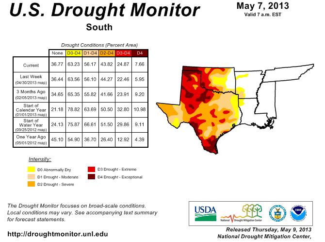
According to the National Drought Monitor, drought conditions worsened in Texas last week, with 12.88% of the state covered by Exceptional Drought, which compares to 10.09% the previous week. Overall, 98.55% of the state is covered by some form of drought, which is unchanged from last week. For the contiguous U.S., the monitor shows slight improvement from last week, with 37.58% of the nation free of drought, compared to 39.88% last week and 40.67% last year at this time.
The monitor notes that while 1 to 6 inches of rain eased Moderate to Exceptional Drought (D1-D4) across the southern third of Texas, scorching heat (highs reaching 97-99°F) extended from the Big Bend northward into eastern New Mexico and the Texas Panhandle. "This heat followed an early-period cold snap, when lows dropped into the teens. With no rain and increasing heat, drought intensity and coverage expanded across the southern half of the High Plains," it states.
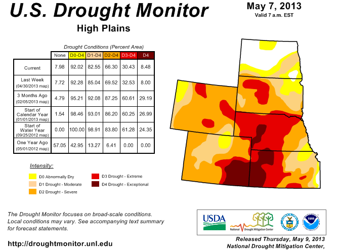
Meanwhile across the Central High Plains, the monitor says rain provided additional drought relief to eastern portions of the region. "Widespread showers (0.75-2.0 inches) in eastern Kansas and southwestern Missouri eased drought, with 2-week totals exceeding 4 inches in eastern-most D0 and D1 areas. Meanwhile, above-normal precipitation in northeastern Colorado improved winter wheat conditions, and drought impacts continued to lessen in this area; consequently, Extreme Drought (D3) was mostly eliminated from this corner of the state. In contrast, dry, hot weather (upper 80s and lower 90s, degrees F) prevailed from Nebraska into southeastern Colorado, where drought intensity either held steady or increased. In particular, Exceptional Drought (D4) expanded across southeastern Colorado," it states.
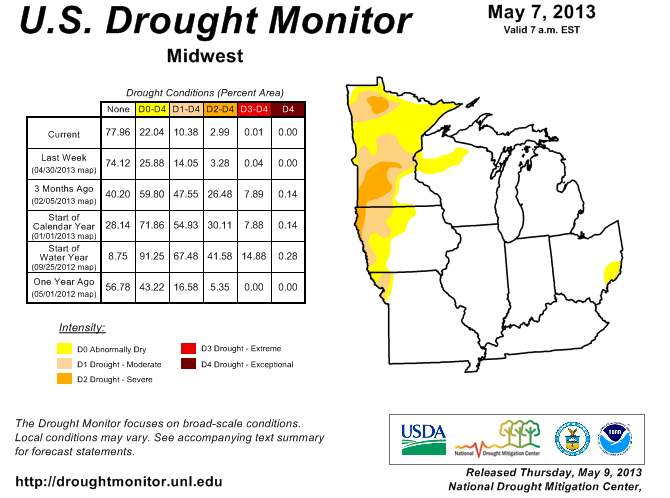
For the Northern Plains and Upper Midwest, the monitor notes that long-term drought lingered despite seasonal snow melt and river flooding, although some improvements were made using updated precipitation data and reports from the field. "A narrow band of 0.50 to 1.50 inches of rain eased D0 (Abnormal Dryness) and D1 (Moderate Drought) from south-central North Dakota into northwestern Minnesota. In addition, updated 90- and 180-day precipitation data supported reducing or eliminating areas of D0 and D1 in southeastern North Dakota and neighboring environs, with totals now at or above 100 percent of normal (locally up to 150 percent) at both time scales," it states. "Likewise, D3 (Extreme Drought) was reduced in northeast Wyoming and southwestern South Dakota, where near-normal precipitation over the past three months has eased drought impacts. Despite the general consensus that conditions continue to improve, long-term indicators, including the 6-, 9-, and 12-month Standardized Precipitation Indices, show underlying, long-term drought persists in the core D1 and D2 areas of the Upper Midwest. In contrast, short-term dryness has reduced soil moisture in north-central North Dakota, where a small area of D0 was added."
In its outlook, the monitor says a developing storm over the nation’s mid-section will become cut off from atmospheric steering, causing the system to drift eastward into the Mid-South by week’s end and the Southeast early next week. "Five-day precipitation totals could reach 2 to 4 inches across the east-central Plains, upper Midwest, lower and middle Mississippi Valley and eastern Gulf Coast region. In addition, late-season snow will fall from the central Rockies into the Upper Midwest. In contrast, little or no precipitation will occur in the Northeast and west of the Rockies. Unusually cool air will trail the storm, resulting in widespread freezes on May 2-3 as far south as the southern High Plains," it predicts. "Warmth will linger, however, from the eastern Corn Belt into the Northeast. The NWS 6- to 10-day outlook for May 7-11 calls for above-normal temperatures in the West and Northeast, while cooler-than-normal conditions will prevail across much of the Corn Belt and from the central and southern Plains into the Southeast. Meanwhile, near- to below-normal precipitation from the Northwest into the northern Plains and western and northern Corn Belt will contrast with wetter-than-normal weather in the central and southern Rockies, portions of the Intermountain West, and much of the eastern third of the nation."