Drought Monitor Reflects Slight Drought Improvement

According to the National Drought Monitor, 39% of the contiguous U.S. is free of drought, which is slight improvement from last week's 38.27%. While drought across the Midwest and the Central and Southern Plains continues to shrink, slight expansion of drought across the South Plains was seen last week.
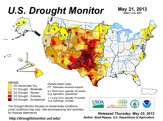
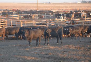
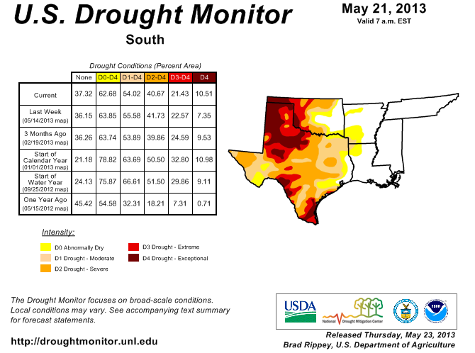
In Texas, the monitor shows the drought area remains intact, but intensity of drought increased. It notes, "The gradient between improving conditions and worsening drought continued to sharpen. A winter-like storm delivered widespread, heavy precipitation (locally 4 inches or more) to the north-central U.S., including the Dakotas and parts of Montana and Nebraska. Significant rain also fell across the southeastern Plains, including central and eastern Oklahoma and northeastern Texas. In contrast, little or no precipitation fell across the southern High Plains. As a result, there were major reductions in drought coverage and intensity on the northern and southeastern Plains, but an increase in the aerial coverage of exceptional drought (D4) and other drought categories on the southern High Plains."
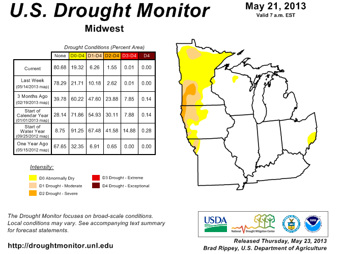
Meanwhile across the Midwest, the monitor shows that 80.68% of the area is now drought-free, which is a two-percentage-point improvement from last week. "Prior to the arrival of wet weather, sharp temperature fluctuations were noted in the upper Midwest. Following a late-season freeze on May 12, temperatures briefly soared. Tekamah, Nebraska, experienced a high of 108°F on May 14, eclipsing its monthly record of 105°F originally set on May 31, 1934. A monthly record from the Dust Bowl era (105°F on May 30, 1934) was also broken in Sioux City, Iowa, where the May 14 high soared to 106°F. In fact, there had never been a reading of 105°F or greater in Iowa before May 29; Sac City had achieved a high of 108°F on May 29, 1934. In Nebraska, records for the earliest triple-digit heat were set on May 14 in locations such as Grand Island (102°F), Omaha (101°F), and Lincoln (100°F); Grand Island’s record had stood since May 20, 1925. Several days later, showers and thunderstorms engulfed the upper Midwest, leading to significant reductions in the coverage and intensity of any lingering drought. Some of the heaviest rain fell in Minnesota, as well as neighboring areas in northern Iowa and northwestern Wisconsin. Rochester, Minnesota, in a part of the state no longer categorized as abnormally dry, set records for May (8.55 inches) and March-May precipitation (18.19 inches). Rochester’s previous records had been 8.41 inches in 1982 and 15.87 inches in 2001, respectively. With a total of 2.43 inches of rain on May 17, Rochester experienced its third-wettest day in May, behind 4.02 inches on May 17, 2000, and 2.97 inches on May 20, 1912," it notes.
In its outlook for May 23-27, the monitor notes a slow-moving storm system that has been affecting the Midwest—and was responsible for the tragic tornado in Moore, Oklahoma—will drift eastward. "The system will reach the Atlantic Seaboard by May 24. Additional rainfall totals—in the form of locally severe thunderstorms—could reach 1 to 3 inches in the Northeast, and cool air will trail the storm into the Midwest and East. Meanwhile, an early-season heat wave will develop on the High Plains. During the Memorial Day weekend (May 25-27), temperatures will approach or reach 100°F as far north as the central High Plains. Elsewhere, cool, showery weather will persist in the Northwest, while thundershowers will return to the Plains. More substantial rain (possibly 1 to 3 inches) may develop during the Memorial Day weekend in the western Corn Belt, including parts of Iowa and eastern Nebraska," it states.